/
United Kingdom
/
Scotland
/
Highland
/
Fort William
/
Excursiones y actividades
/


Paseo en grupo por hacia la cima del Ben Nevis desde Fort William
1 day
Caminando
Grupo
Acerca de esta actividad
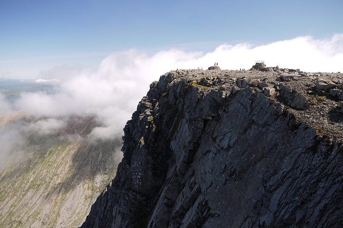
Ben Nevis no solo es el punto más alto del Reino Unido, sino que también alberga algunas de las plantas más raras del Reino Unido y siempre ha desempeñado un papel central en el desarrollo del montañismo en todo el mundo. No solo escale Ben Nevis, ¡descubra más mientras aprende sobre su historia, geología, flora y fauna!
Si está en forma y las condiciones son buenas, debería caminar hasta Ben Nevis en una caminata de seis u ocho horas, pero nunca debe tomarlo a la ligera. Una buena planificación y preparación son vitales: las condiciones pueden cambiar drásticamente incluso con las mejores condiciones meteorológicas.
El camino de la montaña comienza en Glen Nevis y está a unos 16 km (10 millas) de ida y vuelta. Sube 1300 m en una experiencia de montaña completa que requiere botas resistentes y un buen equipo. Puede haber parches de nieve en la ruta hasta julio o agosto y la cima es regularmente 9º C más fría que a nivel del mar. Entonces, si hace cálidos 18º C en Fort William, podría haber 9º C en la parte superior, además de que el viento helado provocaría que se sintiera todavía mucho más frío.
Leer más
Mostrar menos
Si está en forma y las condiciones son buenas, debería caminar hasta Ben Nevis en una caminata de seis u ocho horas, pero nunca debe tomarlo a la ligera. Una buena planificación y preparación son vitales: las condiciones pueden cambiar drásticamente incluso con las mejores condiciones meteorológicas.
El camino de la montaña comienza en Glen Nevis y está a unos 16 km (10 millas) de ida y vuelta. Sube 1300 m en una experiencia de montaña completa que requiere botas resistentes y un buen equipo. Puede haber parches de nieve en la ruta hasta julio o agosto y la cima es regularmente 9º C más fría que a nivel del mar. Entonces, si hace cálidos 18º C en Fort William, podría haber 9º C en la parte superior, además de que el viento helado provocaría que se sintiera todavía mucho más frío.
Incluido
- Líder de montaña experimentado
No incluido
- Almuerzo
- Transporte entre su alojamiento y el punto de inicio / finalización.
- Seguro de Accidentes Personales
Adicional
- La confirmación se recibirá en un plazo de 48 horas después de hacer la reserva, en función de la disponibilidad
- No es accesible para sillas de ruedas
- Funciona en todas las condiciones climáticas, vístete apropiadamente
- En esta excursión o actividad habrá 10 viajeros como máximo
Características
Turismo
80%
Cultural
55%
Original
35%
Opiniones

Overall speaking, it's a great day to do the summit on a whole-day hike. The ever changing weather itself is the major challenge. It is a bit disappointing that the summit peak is entirely covered by thick fog. I would say, the guide is not entirely necessary, anyone who has experience in hiking should be able to do the summit on their own, following the well-established trail.
Amazing experience! Totally worth the money! Beautiful views during the hike! Makes you feel alive;) And cheers to our guide Rachel who beside being a very nice guide really saved us with her extra gear (gloves, vest , hat and hot juice at the top) - we could not have done it without her!:)
I am 72 years of age when walking the Ben Nevis. I often go on mountain walks averaging about 2000ft ascent and 11 miles long. They are strenuous walks. Ben Nevis is twice the height. However, I have heard that a car has been driven up the Ben Nevis that gave me the illusion that there is a passable track on foot. The weather forecast for the day was not good, with heavy rain and showers forecast in the afternoon. I was kitted in rainproof clothes that was ideal for the day. It was a September day, and the weather was fine in the morning. I met the guide Rich at the starting point near the Ben Nevis Inn. There was only one other walker in our party, he was younger than me. The walk up to the wooden bridge was easy. The view was only to the west and south over the Glen Nevis valley. There are few hills further to the west and south. Farther away around the horizon there were blue mountains shrouded in stratus clouds. Beyond about 200 m elevation, the mountain track or the tourist path we followed is rugged rocky climb. I was able to keep a steady pace without a sign of exhaustion. However, I had limited strength to lift myself up when clambering up a high rise, and mentioned to the guide that there is a tendency to fall back. The walking pole was a help, yet the guide Rich said he is behind me. On this stretch of the track on the south face of the Meall an t-Suidhe we met few men laying stones to improve the path. After the rocky climb, we reached an easy saddle about halfway of the walk. The guide Rich was pleased with my ability to scramble up the rocky ascent. The camera bag swinging from the front and the pain its strap induced on the neck was a distracting impediment. To the north, there is the conspicuous Lochan Meall an t-Suidhe. I took many photographs on the way. After crossing the saddle, we headed along the long ascending path on the western face of the Carn Dearg where we also cross the Red Burn a small river, prominent feature of tourist path landscape. At the end of this long stretch, is the beginning of the zigzag path. I felt the air bit chilly but my jacket was fine for the walk, bearing in mind that jackets can make excessively hot and sweaty on mountain walks. As we continued up the zigzag track, even though the scree path was easy to walk on, I was unable to ascend continually at steady pace. I chose to stop at every corner that also served as a moment to take photos of the path. The pace of the walk was, sprint start that quickly slows down for a brief respite. According to the guide, we were neither fast nor slow and he was happy with our pace. After the zigzag, we conquered an ascent straight up, and reached the Ben Nevis summit plateau covered in boulders. The guide showed us two gullies on the north face. On the summit, there are ruins of a hotel, remnant room of the old observatory, and the Trig Point built on a pedestal at an altitude of 1344 m. We took 4.5 hours to ascend. The summit was misty as seen on the photos. Visibility was good for the eye, however not for the camera. Mist was pronounce around the summit, there was no view of scenery around the summit. After a short stop for lunch, we started a brisk descent. On the lower part of the zigzag path, we met the forecast rain. It did not last long and I was able to continue taking photos. On the descent over the rugged rocky track, I felt a pain in the calves that was not a usual symptom. The usual pain in the feet was pronounce. Rocks can be slippery. The legs were teetering on the verge of instability. The walking pole is more helpful in the descent and virtually indispensable for me. We descended in 3.5 hours. Unusually, I did not feel any pain or discomfort after we returned to the base or on the following day. With regard to the story of car driven up the Ben Nevis, there is no evidence of this. However, there is a film clip on YouTube of a Ford model T driven down the snowy Ben Nevis in the 1911.
Connor was AWESOME! Loved him! Very knowledgeable and surefooted but fun at the same time. Great day even if it did rain. Part of the charm!
Wonderful tour. I will certainly recommended to friends of mine with a similar hobby